best rate + insurance coverage
best rate + insurance coverage
WHAT TO DO
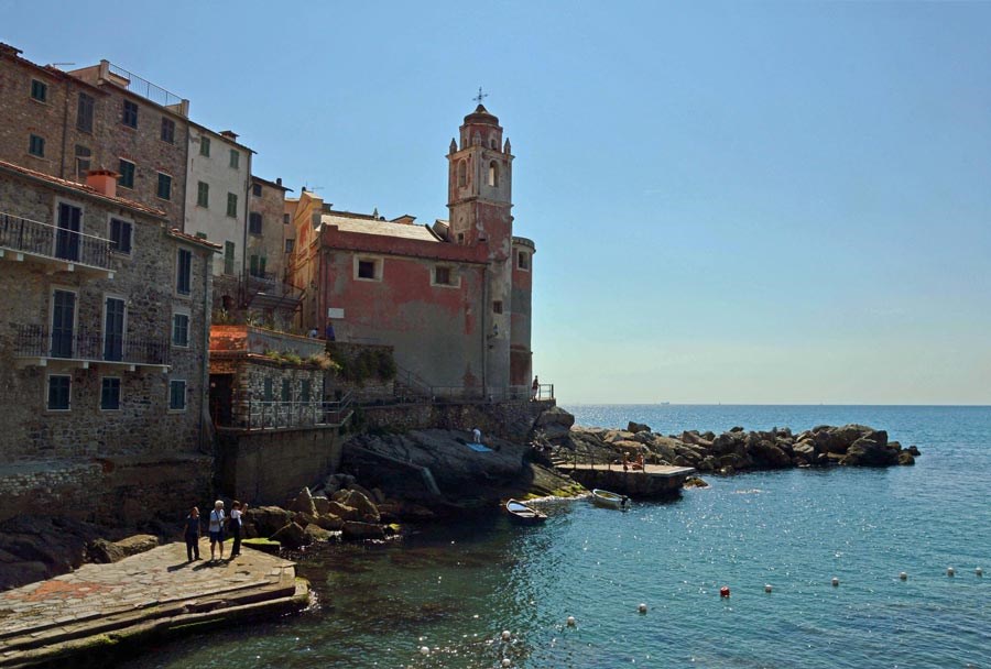
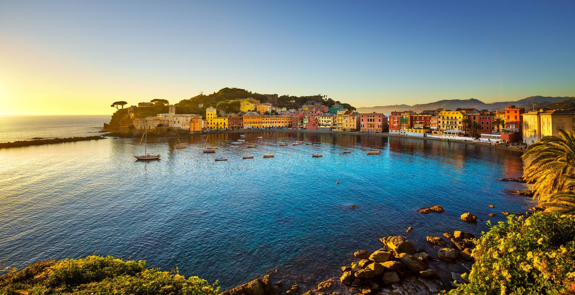
Stage of the Verdeazzurro path, Deiva Marina is well connected to the network of paths that lead from Sestri Levante to Portovenere. Starting from Deiva Marina towards Cinque Terre, Framura can be reached in about 2 hours of walking and Moneglia, towards Genoa, in about 1h,30/2 hours. From Framura you can continue walking to Bonassola, Levanto and then to Monterosso, Vernazza, Corniglia, Manarola, Riomaggiore and Portovenere. From Moneglia you can continue further up to Riva Trigoso and Sestri Levante and then come back perhaps by train, in a few minutes. Unlike the Sentiero Azzurro that connects Monterosso to Riomaggiore, to access which you need to purchase the Cinque Terre Card, the trails in Deiva Marina and its surroundings are totally free of charge and open all year roud.
trekking
Difficulty: low - KM 2,5 - 1h 30’
The footpath leaves from the town of Monterosso and goes up until reaching a crossing indicated by big iron cross. From here climb along a steep staircase until a small chapel (414 metres above sea level). The path continues for abut 50 metres until the Madonna di Soviore Sanctuary (470 metres above sea level), where a hostel is located. The Sanctuary is the most ancient in Liguria and it is particularly interesting because recent investigations discovered an older church, maybe dating back to the middle Ages, whose remains are visible through glasses on the pavement.
Difficulty: low - KM 2 - 45’
Leaving the Madonna di Soviore Sanctuary you continue along a paved road until Colla di Gritta. Reach the refreshing area of a restaurant and from there enter into a wood to go out from the western part overlooking the sea of Levanto. The footpath continues to reach the Mount Vé (or Focone), located 487 metres above sea level, from where you walk down through the col of S. Antonio al Mesco.
Difficulty: low - KM 4 - 2h
From the col of S. Antonio al Mesco walk along an octagonal signal-tower from where the descent towards Levanto begins.
By the Giada del Mesco the path continues the descent meeting Massola House, where in 1931 Guglielmo Marconi perfected his short-wave radio-telephony experiments between Levanto and Santa Margherita.
From here you will reach the eastern outskirts of Levanto from where, through a staircase you can arrive to the “Pietra” seafront.
Difficulty: low - KM 2,4 - 1h 30’
From the area of Vallesanta on the west side of Levanto climb through olive trees and pines until you reach the col of Scernio (183 metres above sea level): here the path continues to climb until you reach the hamlet of Poggio. From that very small town the paths begins to go down and it arrives until the staircase of Maxinara Street from where the east footpath toward Bonassola begins.
Difficulty: medium - KM 4,5 - 2h 30’
From Bonassola reach the street to the churchyard from where a you find a path crossing the road you have to follow until a long slope paved with cement. From here reach the col of Carpeneggio (132 metres above sea level) from where, through an easy trail, you pass a sign indicating the town of Framura. Walk about 200 metres on the flat and go up through a thick vegetation composed by pines and holm-oaks. Then reach the locality of Salice and after that continue towards a group of abandoned houses from where there are small hairpin bends leading to Rio Valle delle Lame. You reach first the hamlet of Anzo and then Ravecca and continuing for about 200 metres uphill you will arrive in Setta di Framura.
Difficulty: low - About KM 4,5 - 2h 30’
Leaving Framura railway station you will arrive in ten minutes through a steep staircase in the hamlet of Anzo (76 metres above sea level), where it is visible an old sighting-tower. Continuing uphill you take the long staircase on the right leading to Ravecca from where you proceed until the third hamlet of Framura, Setta (152 metres above sea level). The trail continues on a paved street until a junction where you have to turn left in order to reach Deiva.
The descent is very steep and abrupt but it offers wonderful panoramas: during limpid days you can see, besides Deiva’s beach, the snow-covered peaks of the Alps.
Difficulty: medium - About KM 4 - 2h
Leaving from the old town of Deiva Marina reach the Square where the post office is located; proceeding along the road reach the locality “Castagnole” and continue boarding a vineyard; a little bit further there is a junction and continue to the right (trail mark: blue ball).
The first part is an unsurfaced road that goes uphill very steep, until reaching the valley of Rio Posacqua and after that a homestead. Now the road becomes a mule-track curling along a magnificent olive-yard.
From here climb until the highest point of the trail (318 metres above sea level), surpass the Rio Crocetta and reach a second prominent hump. Arrive in the town of Moneglia and continue along the carriageable road overlooking the gulf of Moneglia until you reach a large pedestrian street made of wide shallow steps leading to the town.
Difficulty: medium - About KM 20 - 8h
From Deiva Marina railway station walk along Corso Italia in direction to the Motorway. At about three Km from the railway bridge you meet the camping Valdeiva; from here begin to climb crossing the village of Carmagnola and proceed northwards towards Sant’Agata mountain. After a farm you arrive on the provincial road and you can decide to stop for a while by a white marble pit, where it is possible to see a goodly colony of newts, or you can climb until the top of Sant’Agata mountain to see the ruins of an ancient medieval tower and a church.
Continuing along the provincial road you will meet the main road; turning right you will reach the top of San Nicolao mountain from where you can enjoy a unique panorama. Begin the descent following the signs and turn left towards Moneglia. During the trail you will meet the ruins of a medieval church and a splendid chestnut grove. Proceed facing the sea walking along multicolour rocks until you come back on the main road nearby the locality Casa Marcone. From here you can continue along the wonderful ridge leading to Incisa pass and then to Deiva or Moneglia.
Difficulty: medium - About KM 10 - 5h 30’
From Moneglia railway station take the road towards the sea; at the first curve you find on the right hand side a staircase from which the footpath until Moneglia mountain leaves (trail mark: two red X). The track continues uphill until reaching the flat and wooded top of Servagli mountain (327 metres above sea level) walking along the wide peak. Arriving in the Comunaglia mountain (463 metres above sea level) walk along the peak along a narrow path leading to Moneglia mountain (512 metres above sea level).
Continuing along the path towards Casazza (trail mark: two red rhombus) arrive in a small glade where you take the path to Riva Trigoso (two res circles) that goes down rapidly inside the wood. At the junction turn right and cross a glade with picnic area, continue on a trail (two red circles) going down with magnificent views over Punta Manara and Sestri Levante. At the junction turn right on the path towards Punta Baffe and in short you will see the tower with the same name from where you can enjoy an outstanding view over Riva Trigoso.
Coming back to the path our itinerary turn left and begins to go down among heath, strawberry trees and breathtaking panoramas. The path is first unsurfaced ad then asphalted and wider and in a couple of curves leads to the provincial road to Riva Trigoso.
Difficulty: low - About Km 4 - 2 h 15’
It is a brief and relaxing excursion that offers splendid panoramas over the sea. At the Exit of Sestri Levante (Motorway Genoa-La Spezia) continue until the centre of the town. Trail mark: two red full circles. Go along for about 100 metres southward the beaten-earth path and then continue along a small lane on the left. The path continues uphill through some stone steps, meets a small chapel and then crosses the south-eastern hillside of Castello mountain, and finally arrives to the rocky Punta Manara.
Going back you walk along the same path, then turn left on another track (trail mark two full red squares) leading to Sestri Levante. In the last part the path inserts in a alley that goes down until the centre of the town.
Trail mark: white and red
Difficulty: medium - 1h 45’
Leave from the churchyard of Montemarcello and go down along a staircase. At the end of it cross the surfaced road and continue downhill. Go up among olive trees and fields and enjoy the panorama of the island of the gulf of La Spezia.
Proceed until you arrive nearby a rural building, board it and continues towards Lerici.
The track is easy to recognize for the stone surface and the two dry walls bordering it. After the last part among oak trees and Aleppo pines the path crosses the surfaced road again and continues along a olive yard until reaching a flat area with an unforgettable beauty spot.
Proceed towards Lerici and after a short track among houses and walls, reach the locality Quatro Strade, cross the road and continue along the path bordered by dry walls that leads to Tellaro. Go down along the steep staircase of so-called “Piastron”, a precipice overlooking the sea. On the right of the path large olive yards arrive until the first houses of the town, enter to the historical centre until the small harbour.
This road has a huge historical importance and crosses the present Lunigiana, touching the provinces of La Spezia and Massa Carrara. In the antiquities the road connected Canterbury in England with Rome. Its story began with the Longobard rule, it was used as commercial and communication way between the plain and their main harbour, nearby the actual Bocca di Magra. Successively the way was enlarged by the Franks that made it famous: in that period it began to be used by the pilgrims who wanted to reach Rome. Some parts of it are still nowadays passable on foot or by bicycle: in the area of Berceto you can do excursions of unforgettable beauty and also full of mysticism.
What to do